Photo: Messenger
Bangladesh has become increasingly susceptible to earthquakes, with the fear escalating day by day as mild and moderate tremors are occasionally felt in the country – thereby numbering 11 in last 11 months.
Although these instances have not resulted in significant damages as of now, experts have expressed concerns about potential extensive damage in the event of a large-scale earthquake. Despite the absence of major earthquakes in recent times, Bangladesh remains at risk due to its geographical location.
It has been known that a staggering total of 11 mild and moderate earthquakes have jolted Bangladesh so far this year. Earthquake experts warned that these earthquakes occur frequently due to the opposing movement of the Burmese plate and the Indian plate. A large amount of energy is stored at the junction of these two plates, seeking a way out. Sooner or later, this energy will be released, and these small earthquakes are precursors to larger earthquakes.
Despite the risk of earthquakes, preparedness is very low. According to experts, the risk is exacerbated by many old buildings, the construction of unplanned structures, and a lack of adherence to building codes. Without proper measures taken in a timely manner, the country could face a major disaster.
Mehedi Ahmed Ansary, a Professor in the Civil Engineering Department at Bangladesh University of Engineering and Technology (BUET), told The Daily Messenger, “Small and medium earthquakes indicate a tendency to release large amounts of energy. This means a major earthquake can occur at any time. However, it cannot be predicted when this significant earthquake will happen.”
A joint study by Columbia University and Dhaka University found that Bangladesh is located at the junction of three plates—the Indian plate to the north, the Burma plate to the east, and the Asia plate. The junction of the India plate and Burma plate lies within Bangladesh, forming a subduction zone that passes through Sunamganj and Kishoreganj haor, through the Meghna River to Sumatra in the Bay of Bengal.
Plates in subduction zones are very dangerous, causing significant damage to life and property. During a research period from 2003 to 2007, about 25 GPS devices were installed in different places. Analysing the data, geologists found that the subduction zone has a magnitude of 8.2 to 9, and this energy can be released at any time.
Researchers revealed two sources of major earthquakes within Bangladesh—the Dauki Fault and the subduction zone from Sylhet in the north to Teknaf in Cox's Bazar in the south. The subduction zone is considered the most dangerous.
This subduction zone has not experienced any major earthquakes in the last 800 to 1,000 years. An earthquake of magnitude 8.5 occurred in 1762 in the Myanmar part from Teknaf to the south. In that earthquake, the island of St. Martin rose three meters. Moreover, mud sands are outcropped in Sitakunda Hills. The energy that has accumulated in the area from Sylhet to Cox's Bazar has not been released until now, which is an ominous sign for Bangladesh.
Geologist and former director of Earth Observatory of Dhaka University, Professor Dr. Syed Humayun Akhter, told The Daily Messenger, “Before a major earthquake occurs in any place, some small earthquakes happen. Again, suddenly the power is released. Recently, 11 mild and moderate earthquakes have occurred in different parts of the country, all falling within subduction zones. These are signs of a major earthquake.”
He also said that energy has been stored in the subduction zone from Sylhet to Cox's Bazar, capable of causing earthquakes with a magnitude greater than 8. At any time, this energy can be released all at once or in stages. The distance from the capital to the source of the Dauki Fault is 150 km, and the subduction zone of the India and Burma plates is at least 70 km.
However, the most significant damage will likely occur in Dhaka, the capital city. Dhaka is the most populous city in the country, and urbanisation there is uncontrolled and unplanned. Many structures are also weak. Wherever the population is high, the risk of earthquakes increases. All the elements needed to increase the risk are present in Dhaka, making it the most vulnerable. If there is an earthquake with a magnitude greater than 8, it will be challenging for Dhaka city to recover from the damage, he added.
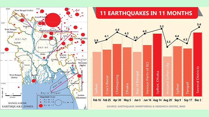
11 earthquakes in 11 months
The first earthquake of the year was felt on February 16. Along with India’s northeastern state of Meghalaya, Bangladesh’s northeastern Sylhet district was also affected. The 3.9-magnitude earthquake caused no damage to life and property. Then, on February 25, a pair of moderate earthquakes hit Myanmar. The earthquake was felt in Ayawati and Rakhine states of the country, as well as in Cox’s Bazar in Bangladesh, with a magnitude of 4.1 on the Richter scale.
A 4.6-magnitude earthquake was felt in Chattogram on April 30. Its origin was Maulai in eastern Myanmar, located 400 km southeast from the earthquake monitoring and research centre of the capital. Another earthquake, with a magnitude of 4.3, was felt in the capital on May 5. The epicentre was Dohar, 30 km southeast of the city centre of Dhaka.
On June 5, a 3.9-magnitude earthquake hit the Bay of Bengal. The epicentre was at the bottom of the Bay of Bengal near Myanmar. On June 16, an earthquake was felt in various parts of the country, including the capital Dhaka, originating from Golapganj in Sylhet, with a magnitude of 4.5.
On August 14, a 5.5-magnitude earthquake was felt in Sylhet, affecting some districts, including Dhaka. The origin was Meghalaya in Assam, with a depth of 35 km. The distance from Dhaka to the origin was 228 km northeast. Just 16 days later, on August 29, mild tremors were again felt around the city of Sylhet, with a magnitude of 3.5. The origin was Jaintapur in the Meghalaya state of India.
On September 9, a 4.4-magnitude earthquake struck northeastern India’s Assam state, also shaking Sylhet district in Bangladesh. The distance from Dhaka to the origin was 263 km northeast in Kachar, Assam, India. A 4.2-magnitude earthquake was felt in Tangail on September 17, with the origin at Tangail Sadar, 59 km away from Dhaka, and a depth of 5 km.
Finally, on Saturday (December 2), an earthquake was felt in several districts of the country, including the capital Dhaka, at 9:36 am. This moderate earthquake lasted for a few seconds, with a magnitude of 5.6 on the Richter scale. The epicentre was in the Ramganj area of Lakshmipur, 86 km southeast of Bangladesh Meteorological Department’s earthquake measuring station, at a depth of 10 km below the surface.
Messenger/Sun Yath


